Cles | Telefono: +39 0463 536221 | Cellulare: +39 3333092573
![]()
![]()
![]()


-
€ 80. soci CAI/DAV e similari: € 58.
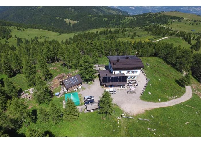
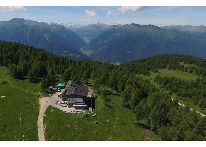
At the foot of Mount Peller, there is the refuge which represents the northernmost gateway to the Brenta Dolomites group and overlooks the Non Valley, on a hill overlooking the Durigal lakes. The refuge is the starting point of numerous crossings and excursions with reaching the top of Mount Peller in just 60 minutes. The Peller refuge, with its 31 beds, is a destination and base for hikers, mountaineers and bikers looking for peace and excitement on a natural viewpoint with a breathtaking view.
Read everythingIt is possible to reach the Peller refuge via three main paths: O313: Ancient access route to the vast meadow plateau of the "Cles mountain" and to the Péller refuge. The construction of the access road to the mountain, with which it shares a large part of the route at altitude, has significantly reduced its use for excursions. From the Bersaglio locality, located 2 km from the center of Cles on the road that leads to the Péller Refuge, take a narrow dirt road that enters the woods and leads to the nearby Crosetta locality where, on the left, the "Senter de la Bepina" forks (number 313B) which also goes up the mountain. At the crossroads, turn right and you will soon reach the beautiful grassy knoll of Malga Boiara Bassa; just above, you intersect the road that goes up to the Péller Refuge and take a small road that goes up to cross, in the Bronzoi area, the Sant'Antonio forest road. The route continues in the woods, re-crossing the road to Péller (altitude 1390 m) and, having completed a long diagonal which offers some beautiful views of the valley and towards the coast of the Anaunia mountains, in the Prese area, it joins the road to the Péller refuge which, from here on out, he follows faithfully. This runs along the basin of Lake Verdè, passes by the crossroads of Fontana Maora, where from the left it intercepts the "Senter de la Bepina" and, with a route that alternates stretches in the woods with large, open pastures, leads to the car parks near Lake Dorigat (Durigal) on the edge of a vast basin at the foot of the eastern slope of Monte Péller. Here you leave itinerary 336 to the left for Malga Tassulla and Pian della Nana: continue on the cemented road that goes up the panoramic grassy ridge and arrives at the clearing below the Péller Refuge. The last stretch that leads to the SAT refuge takes place on the path that goes around the southern side of the hill on which the building is located, the starting point for the top of Monte Péller. O313B: Historical itinerary used by the inhabitants of Cles to reach the Montagna di Cles plateau. Alternative and more direct than itinerary 313, you can combine it with a circular excursion. From Bersaglio you can quickly reach, via itinerary 313, the Crosetta crossroads where, on the left, our path begins. The route follows a steep tractor road that rises diagonally into the woods and, after having crossed the forest road that comes from Mechel, it intersects with another small road (1320 m. altitude) connected to the nearby 2nd hairpin bend of the road to Péller. From here the path enters the bed of a small valley on a flat surface, then climbs up the opposite steep slope, finding the crossroads with itinerary 373 coming from Ciaretar di Tuenno and, a little further on, joins the forest road that goes up from Tuenno. Following the dirt road you arrive on the beautiful grassy plateaus of Campo di Nanno, after passing which, you go up again within a wooded area, the last one before finally exiting into the open air, onto the vast pastures of the Tassullo Mountain. Having reached the crossroads at an altitude of 1630, the trail sign leaves the road and, taking a partly cemented tractor road that rises gently up the valley above, leads to a hut; follows a short stretch of path and again a narrow cart track that leads to the main ridge. Dropping slightly onto the opposite side, you reach the Fontana Maora crossroads, joining the road that leads to the Péller Refuge (trail sign 313). O308: Long itinerary that from the bottom of Val di Sole, in front of the town of Malè, goes up the vast fir woods that surround the ridge of Pra de la Selva and leads to the pastures of Malga Clesera and to Lago delle Salare, among the meadows W of Mount Péller. The path begins in Baita Regazzini, on the right bank. of the Noce River, reachable from Molini di Malè. On the meadow above the car park you will find the signs for our path, together with those for itinerary 374 which, to the left, goes up to the Mezol Refuge. Go to the right, rising into the woods along a forest road or along shortcuts to it, until its end (1130 metres); continue on a mule track that goes up with numerous turns up to Pra de la Selva, where you come across another forest road which, towards the left, leads to the Mezol bivouac, while on the right it goes up into the coniferous woods of Cune. Follow the latter up to Cune, at the intersection with itinerary 308B, where a path begins that crosses the Selva Alta woods and emerges at the lower edge of the Malga Clesera pastures. At the side of the mountain hut, take a small road that goes around a hill and enters the beautiful grassy valley and leads, first into the valley (2000 m) below the Forcola Pass (signs on the left), and then to Lago delle Salare, a small mirror of water that dries up during periods of drought; here a second path converges from the left coming from the Forcola Pass. With an open and pleasant route, the path rises on the panoramic ridge to the N of Monte Palon, then crossing vast pastures up to the head of the Val dei Cavai where it meets itinerary 335 which connects Carciato to the Nana Pass.
Read everything31 beds distributed over two floors in rooms for 4/6 people, with a bathroom/shower service on each floor.
Read everythingIn addition to the paths described to reach the Peller Refuge, you can reach the top of Mount Peller via the equipped Stringari path which can be done in an hour. A nice tour around the mountain covering a total of about 14 km passing through the Clesera hut, the Salare lake and the Nana pass, returning with path no. 337 towards Malga Tassulla and Peller refuge; the tour can also be done in the other direction. The most challenging and fascinating crossing is through the "Sentiero delle Palete" which is a path equipped for expert hikers and arrives at the Grosté pass. an easier alternative is the famous Costanzi path for a total of 13 hours of walking, with the possibility of a break at the Fratelli Bonvecchio bivouac.
Read everythingFrom June 20th to September 20th Further openings will be possible depending on weather conditions.

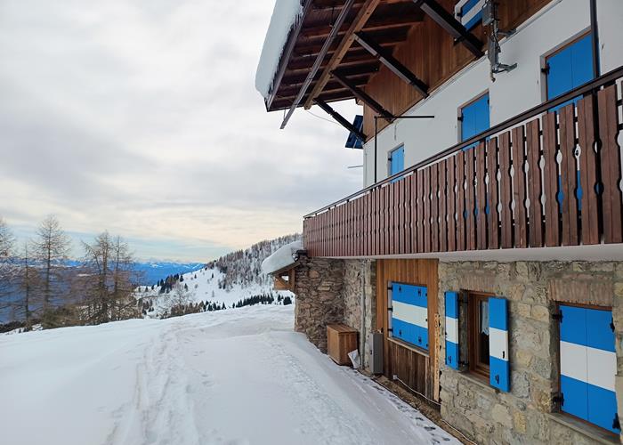
The new management of the Peller refuge will be happy to welcome you in the best possible way in a mountaineering refuge style. It will delight you with dishes prepared by our chef and with typical Trentino natural products. You can spend a moment of peace and tranquility with us immersed in the nature of the Brenta Dolomites, with a view of a fabulous 360 degree panorama! we are waiting for you! Manuela and Rivael
Enter our shop to buy your stay in one of the mountain shelters that are part of mountbnb.
Buy now
![]()
![]()